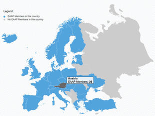
Interactive SVG map
16 January 2017

For one of our clients, EAAP, we've created a customised SVG map of Europe which connects to their membership database to determine which countries to highlight and the numbers to display as tooltips.
Scalable Vector Graphics (SVG) is an XML-based vector image format for two-dimensional graphics with support for interactivity and animation.
The previous Google GeoMap solution was deemed unsuitable as it excluded Turkey from continental Europe. The SVG map is also much faster as it's hosted locally and only requires around 40kb of data to be transferred to the browser.
The map details will automatically update as new members sign up from other countries.
Please get in touch if you're interested in something like this for your website.